


Mobile Topographer


Mobile Topographer의 설명
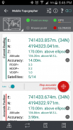
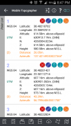
Your mobile Topographer!***Increase GPS accuracy using:- Weighted averaging (on every axis).
- Map calibration.
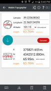
- Device calibration on map, or on a know point.***Display and convert GPS geodetic to cartesian EN coordinates and back:- UTM support.
- Europe ETRS89/UTMZ28-38 support.
- Hellas Geodetic Reference System HGRS 87 (GGRS87 - EGSA 87 - ΕΓΣΑ 87) support.
- Hellas HTRS07/TM07 support.
- Iceland ISN93 / Lambert 93 support.
- Morroco Merchich CS support
- SPCS83 (124 zones) USA support
- Romania S-42(58)/Stereo 70 support
- Lebanon & Syria Deir ez Zor / Stereographic support
- Croatia HTRS96 / Transverse Mercator support
- Serbia SRB-ETRS89/UTM (Current CRS) & SRB-MGI/Z7 (Old CRS) support
- Australia MGA94 (GDA94) (Current CRS) & AMG66 (AGD66) (Old CRS) National, A.C.T., Northern Territory, NSW & Victoria, Tasmania & AMG84 (AGD84)support
- MGI Balkans zones 5,6 & 7 (Former FR of Yogoslavia) support.
- Italy's Monte Mario West Zone 1 Peninsular, West Zone 1 Sardina, East Zone 2 Peninsular, East Zone 2 Sicily support.
- Costa Rica's CΜ05/CRTM05, Ocotepeque 1935 Costa Rica Norte & Ocotepeque 1935 Costa Rica Sur support.
- Cyprus' CGRS-93-LTM support.
- Hungury's HD72/EOV support.
- Kosovo's KosovaREF01 support.
- Latvia's LKS92/TM support.
- Lithuania's LKS94/TM support.
- Spain's ED50/UTMZ29-30 NW, ED50/UTMZ29-31 ML (Spain old Mainland), ED50/UTMZ31 BA (Spain old Balearic) support.
- Uk's OSTN02/OSGM02 support.
- Turkey's ED50/Gauss-Kruger 3° Z9-15 & ITRF96 & ED50/UTMZ35-38 support.
- Luxembourg's LUREF support.
- Venezuala's REGVEN/Z18-20 support.
- Sweden's SWEREF99 TM support.
- Argentina's POSGAR 94 (old) & POSGAR 2007 (new) support.
- India's Kalianpur 1975 ZI - ZIV support.***Multiple units support:- Metres,
- International feet,
- US survey feett.***Height calculation:- Ellispoidal height.
- EGM96 orthometric height calculation.***Convert from geodetic to cartesian coordinates and back:
- Support for device measured points, or
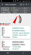
- Manualy input of geodetic or cartesian coords.***Drive me:- Key in coordinates of the target point in either geodetic or cartesian coordinates, or select a point from the list and follow the pointer.
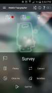
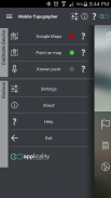
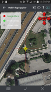
- Compass indicating both magnetic and true North.***Project on Map:- Project individual points on any map application.
- Project list of points, and the defined polygon, on embeded Google maps.***Save multiple point lists, to use them later.***Calculate area.***Export point lists το:- .txt (text file)
- .csv (point file - comma seperated)
- .kml (google earth file)
- .dxf (drawing file)***Send file via e-mail, or upload it to Google Drive, Dropbox, etc.***Complete help text support.Help us improve Mobile Topographer by e-mailing your comments and suggestions.Tags: GPS ΕΓΣΑ ΕΓΣΑ87 EGSA EGSA87 GGRS GGRS87 HGRS HGRS87 HTRS07 HTRS UTM ISN93 TOPO ΤΟΠΟ ΤΟΠΟΓΡΑΦΙΚΟ TOPOGRAPHIC coords KTIMATOLOGIO ΚΤΗΜΑΤΟΛΟΓΙΟ TOPOGRAPHER ΕΜΒΑΔΟ AREA SURVEY의귀하의 모바일 지형학
의*** 사용하여 GPS 정확도를 향상에:
- (모든 축) 가중 평균.
-지도 교정.
-지도, 또는 알고 지점의 장치 교정.
의***디스플레이 및 직교 EN에 GPS 측지 변환 다시 조정하고
- UTM을 지원합니다.
- 유럽 ETRS89/UTMZ28-38 지원.
- 헬라스 측지 참조 시스템 HGRS 87 (GGRS87 - EGSA 87 - ΕΓΣΑ 87)을 지원합니다.
- 헬라스 HTRS07/TM07 지원.
- 아이슬란드 ISN93 / 램버트 93을 지원합니다.
- 모로코 Merchich CS 지원
- SPCS83 (124 구역) 미국 지원
- 루마니아 S-42 (58) / 스테레오 70 지원
- 레바논 및 시리아의 데이 르 EZ ZOR / 진 Stereographic 지원
- 크로아티아 HTRS96 / 횡 메르카토르 지원
- 세르비아 SRB-ETRS89/UTM (현재 CRS) 및 SRB-MGI/Z7 (구 CRS) 지원
- 호주 MGA94 (GDA94) (현재 CRS) 및 AMG66 (AGD66) (구 CRS) 국립, ACT, 노던 테리토리, NSW & 빅토리아, 태즈 메이 니아 & AMG84 (AGD84) 지원
- MGI 발칸 반도 지역, 6 & 7 (Yogoslavia의 전 FR) 지원.
- 이탈리아의 몬테 마리오 서구 1 반도, 서구 1 사르, 동 지역 2 반도, 동 지역 2 시실리 지원.
- 코스타리카의 CΜ05/CRTM05, Ocotepeque 1935 코스타리카 노르 테 & Ocotepeque 1935 코스타리카 서 지원.
- 키프로스 CGRS-93-LTM을 지원합니다.
- Hungury의 HD72/EOV 지원.
- 코소보의 KosovaREF01 지원.
- 라트비아의 LKS92/TM 지원.
- 리투아니아의 LKS94/TM 지원.
- 스페인의 ED50/UTMZ29-30 NW, ED50/UTMZ29-31 ML (스페인 오래된 본토), ED50/UTMZ31 BA (스페인 오래된 발레 아레스) 지원.
- 영국의 OSTN02/OSGM02 지원.
- 터키의 ED50/Gauss-Kruger 3 ° Z9-15 & ITRF96 & ED50/UTMZ35-38 지원.
- 룩셈부르크의 LUREF 지원.
- Venezuala의 REGVEN/Z18-20 지원.
- 스웨덴의 SWEREF99의 TM을 지원합니다.
- 아르헨티나의 (구) POSGAR 94 & POSGAR 2007 (신규) 지원.
- 인도의 Kalianpur 1975 ZI - ZIV 지원.
의***여러 장치 지원 :
- 미터,
- 국제 발,
- 미국의 조사 feett.
의***높이 계산 :
- Ellispoidal 높이.
- EGM96 표고 계산.
의*** 직교 좌표로 측지 변환 및 백업에:
- 장치의 측정 포인트에 대한 지원
- 측지 또는 직교 좌표입니다의 Manualy는 입력.
의*** 나 드라이브에:
- 측지 또는 직교 좌표 하나의 목표 지점의 좌표를 입력하거나 목록에서 포인트를 선택하고 포인터를 따릅니다.
- 나침반 노스 자기와 사실을 모두 나타낸다.
의***지도에프로젝트 :
- 모든지도 응용 프로그램에 대한 프로젝트 각각의 포인트.
- 임베디드 구글지도 프로젝트 포인트의 목록 및 정의 된 다각형.
의*** 나중에 사용하기 위해 여러 포인트 목록을 저장하는.
의*** 면적을 계산하는.
의***수출 포인트 목록 το :
-. TXT (텍스트 파일)
-. CSV (포인트 파일 - 쉼표로 구분)
-. KML (구글 어스 파일)
-. DXF (도면 파일)
의*** 전자 메일을 통해 파일을 보내거나 등 구글 드라이브, 드롭 박스에 업로드에의***완료 도움말 텍스트를 지원합니다.우리는 여러분의 의견과 제안을 전자 우편으로 모바일, 지형학을 개선하는 데 도움이됩니다.태그 : GPS ΕΓΣΑ ΕΓΣΑ87 EGSA EGSA87 GGRS GGRS87 HGRS HGRS87 HTRS07 HTRS UTM ISN93 TOPO ΤΟΠΟ ΤΟΠΟΓΡΑΦΙΚΟ 지형이 KTIMATOLOGIO ΚΤΗΜΑΤΟΛΟΓΙΟ 지형학 ΕΜΒΑΔΟ AREA 조사를 좌표입니다
Mobile Topographer - 버전 9.3.2
(22-05-2019)

Mobile Topographer - APK 정보
APK 버전: 9.3.2패키지: gr.stasta.mobiletopographerMobile Topographer의 최신 버전
다른 버전들


동일 카테고리의 앱
좋아할 만한 것...
 4.833.434.134.18


